Educational Resources

Looking for information on slopes can be time-consuming and overwhelming, with so many technical terms and guidelines to wade through. And sometimes you just don’t know where to look. So, we’ve compiled a collection of useful information for you to go to as a starting point for your search for information and hopefully answer a question or two that you may have had. We’ve categorized the information for your convenience, so happy browsing!

Existing Slopes

Here are some brochures, posters and guidelines from technical agencies to raise you knowledge about slopes.

LEARN

Learn more about the slopes around you: how they’re made, what makes them unstable, landslide mechanisms, and some key concepts in slope safety.

MONITOR

Find out what are the signs of landslides and know who to call when you see a slope with the signs. Start an early warning system through observations.

MAINTAIN

Maintaining slopes can be done by non-engineers. Check out 10 simple maintenance tips that can be done by residents on a regular basis.

EMERGENCY RESPONSE

Planning for landslide emergencies is a must if you live in hillside areas. Knowing what to do when disaster strikes can save lives and property.

BiGBen–A one-stop centre for general and real-time information on disasters by Public Works Department Malaysia. Read more here

New Slopes

All new slope developments must comply with requirements set in the federal guidelines as well as the state guidelines where the development is proposed.

FEDERAL GUIDELINES

Under Act 172, all development must obtain planning approval before work starts. The development includes any ground modification, including removing the earth or changing the building or any part thereof.

All states require detailed information, analyses and designs upon submission for approval.

KEY POINTS OF THE GUIDELINES

Federal Guidelines for Development in Highland Areas by the Department of Town and Country Planning.

NOTE: “In-situ” means existing slope, in its current condition. 

Slope ClassificationPermitted DevelopmentTechnical Requirements
Class 1
- In-situ terrace with slope < 15°
- Cut slopes with slope < 15°
Lowlands (below 150m) and Hill Land (150m–300m):
May be considered for all types of development subject to the local plan/development plan.

Highlands (300m–1,000m):
- May be considered for low-impact eco-tourism and recreational development (subject to requirements).
- Low-impact community facilities may be considered according to the carrying capacity of the area.

Mountains (above 1,000m):
No development is permitted except for the construction of infrastructure such as roads, tunnels, bridges, telecommunications, and electricity of national importance with low intensity.
a. Geotechnical Investigation Report and Slope Stability Analysis prepared by a geotechnical engineer (soil structure);
b. Geological and Geomorphological Mapping Report prepared by a geologist registered with the Board of Geologists;
c. Drainage and Irrigation Report prepared in accordance with the Manual Saliran Mesra Alam (MSMA) by a hydrological engineer registered with the Department of Irrigation and Drainage (Hydrology);
d. EIA Report prepared by an EIA consultant registered with the Department of Environment for developments exceeding 50 hectares; and
e. Earthwork Plan prepared by an engineer registered with the Board of Engineers Malaysia.

For Class I and Class II, only development projects subject to Section 34A of the Environmental Quality Act 1974 are required to submit an EIA Report.
Class 2
- In-situ terrain with slopes > 15° and < 25° with no signs of erosion or slope instability
- In-situ terrain with slopes < 15° showing signs of erosion and slope instability
- Hilltops or ridges
- In-situ terrain with slopes < 15° consisting of colluvium or geological materials
- Flood hazard areas
Lowlands (below 150m) and Hill Land (150m–300m) (conditions based on elevation):
a. High-density residential
b. Row of shops
c. Office (free-standing)
d. Tourism
e. Training institutions

Highlands (300m–1,000m):
- May be considered for low-impact eco-tourism and recreational development
- Low-impact community facilities may be considered according to the carrying capacity of the area

Mountains (above 1,000m):
No development is permitted except for the construction of infrastructure such as roads, tunnels, bridges, telecommunications, and electricity of national importance with low intensity.
a. Geotechnical Investigation Report and Slope Stability Analysis prepared by a geotechnical engineer (soil structure)
b. Geological and Geomorphological Mapping Report prepared by a geologist registered with the Board of Geologists
c. Drainage and Irrigation Report in accordance with the Manual Saliran Mesra Alam (MSMA) prepared by a hydrological engineer registered with the Department of Irrigation and Drainage (Hydrology)
d. EIA Report prepared by an EIA consultant registered with the Department of Environment for developments exceeding 50 hectares
e. Earthwork Plan prepared by an engineer registered with the Board of Engineers Malaysia

For Class I and Class II, only development projects subject to Section 34A of the Environmental Quality Act 1974 are required to submit an EIA Report.
Class 3
- In-situ terrain with slopes > 25° and < 35° with no signs of erosion or slope instability
- In-situ terrain with slopes > 15° and < 25° showing signs of moderate to severe erosion and slope instability
- In-situ terrain with slopes > 15° and < 25° consisting of colluvium or geologically sensitive materials
- In-situ terrain with slopes < 15° consisting of colluvium or geologically sensitive materials showing signs of slope instability
- Areas consisting of limestone, swamps, peat soil, and former mining land
- Areas prone to mud flood hazards
Lowlands (below 150m) and Hill Land (150m–300m) (conditions based on elevation):
a. Residential
b. Row of shops
c. Office (free-standing)
d. Tourism
e. Training institutions

Highlands (300m–1,000m):
May be considered for low-impact recreational activities that do not involve the construction of built structures. For example, campsites and other conservation-related activities may be considered.

Mountains (above 1,000m):
No development is permitted except for the construction of infrastructure such as roads, tunnels, bridges, telecommunications, and electricity of national importance with low intensity.
a. Geotechnical Investigation Report and Slope Stability Analysis prepared by a geotechnical engineer (soil structure)
b. Geological and Geomorphological Mapping Report prepared by a geologist registered with the Board of Geologists
c. Drainage and Irrigation Report in accordance with the Manual Saliran Mesra Alam (MSMA) prepared by a hydrological engineer registered with the Department of Irrigation and Drainage (Hydrology)
d. EIA Report prepared by an EIA consultant registered with the Department of Environment
e. Earthwork Plan prepared by an engineer registered with the Board of Engineers Malaysia

For Class III, an EIA Report must be prepared for all development projects.
Class 4
- In-situ terrain with slopes > 35° with no signs of erosion or slope instability
- In-situ terrain with slopes > 25° and < 35° showing signs of erosion and slope instability
- In-situ terrain with slopes > 15° and < 25° consisting of colluvium or geologically sensitive materials
- In-situ terrain with slopes > 15° and < 25° consisting of colluvium or geologically sensitive materials showing signs of slope instability
- Areas prone to debris flow hazards
No development is permitted except for the construction of infrastructure such as roads, tunnels, bridges, telecommunications, and electricity of national importance with low intensity.a. Geotechnical Investigation Report and Slope Stability Analysis prepared by a geotechnical engineer (soil structure)
b. Geological and Geomorphological Mapping Report prepared by a geologist registered with the Board of Geologists
c. Drainage and Irrigation Report in accordance with the Manual Saliran Mesra Alam (MSMA) prepared by a hydrological engineer registered with the Department of Irrigation and Drainage (Hydrology)
d. EIA Report prepared by an EIA consultant registered with the Department of Environment
e. Earthwork Plan prepared by an engineer registered with the Board of Engineers Malaysia

A detailed EIA report for areas above 1,000m and for Class IV infrastructure-related developments must be prepared by an EIA consultant approved by the Department of Environment. All technical reports must be reviewed by the relevant Technical Departments.
Additional Conditions for All Classes:
i. Other developments, apart from those provided under subsection 22(2A) of Act 172, may be considered by the State Authority and must be submitted to the National Physical Planning Council (MPFN) for advice;
ii. Comprehensive engineering planning and architectural studies must be carried out;
iii. The latest environmentally friendly technology must be used;
iv. Developments to be implemented must take into account aspects of maintenance, supervision, monitoring, and enforcement;
v. Developers must obtain insurance or a bond to ensure accountability for the development undertaken;
vi. Developers shall be responsible for the constructed slopes, and this condition must be included as one of the requirements during the consideration of the planning permission application;
vii. Consultants conducting the studies must be competent, reputable, experienced, and appropriately qualified;
viii. Consideration must be given to the loading factor of development in hilly areas; and
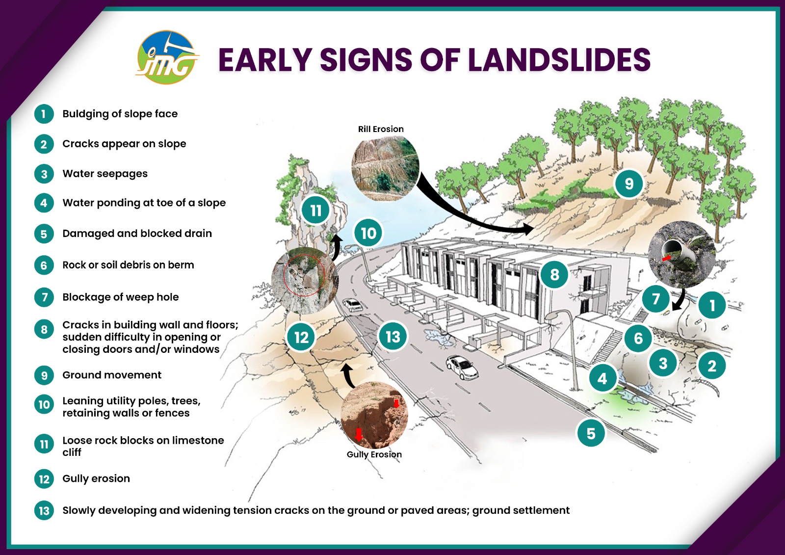
ix. Engineering requirements must be tightened for developments in highland areas, and slopes must be inspected every five years.

STATE GUIDELINES

OTHER GUIDELINES

All new slope developments must comply with requirements set in the federal guidelines as well as the state guidelines where the development is proposed.

PLANNING AND APPROVAL FOR SLOPE WORKS AND HILLSIDE DEVELOPMENT

Geology

Geology and underground water plays a big role in the stability of your slopes. Learn more about what is below the ground under your feet. 

Malaysia Geotechnical Information Management System (MyGEMS) is an online platform developed to collect, store, and share geotechnical and slope-related data in Malaysia.  It consists of a centralized database, decision support tools to help experts assess slope safety, conduct monitoring and maintenance of slopes. It also helps engineers, planners and local authorities make informed decisions for hillside development, slope stabilization, and disaster risk reduction.

For the general public, there are plenty of information and maps covering a wide range of topics, from groundwater to mineral resources to geoparks and geological formations.

Trees and Plants on Slopes

One of the frequently asked questions by residents is: what vegetation or trees are best for slopes?  Read what arborists recommend.

WHAT PLANTS ARE GOOD FOR SLOPES?

Vetiver grass is excellent for slopes because of its very deep, strong root system (up to 3–4 meters deep). These roots bind the soil tightly, making it resistant to erosion and landslides. The grass grows in dense clumps, which slows down surface water runoff, reduces soil loss, and helps water soak into the ground.

FIND OUT MORE ABOUT TREES FROM THE  MALAYSIA SOCIETY OF ARBORISTS

Publications

Slopes Made Simple by Ir Shaik Abdul Wahed Dato’ Hj. Rahim is a practical, visual guide that breaks down slope engineering and maintenance concepts into manageable, real-world lessons—empowering both laypeople and professionals to better understand and manage slope-related risks.

Two Decades from the Indian Ocean Tsunami: Key Challenges and Advancements provides a series of reflections and analyses of the developments of disaster risk reduction following the 2004 Indian Ocean tsunami. The chapter, “Development and Progress of Community-Based Disaster Risk Reduction in Malaysia,” co-authored by Takako Izumi and Eriko Motoyama, focuses on Malaysia’s approach to mitigating the risks of natural disasters such as floods and landslides. 

Community Initiatives

COMMUNITY DISASTER RISK REDUCTION (DRR) RESOURCE CENTRE 

The idea of the Community DRR Resource Centre came from the residents of Ulu Klang under the SeDAR JICA Partnership Program. The DRR Centre is where communities and the general public can learn about disaster risk reduction, focusing on preparedness and mitigation.

The Centre is located in a community hall in Bukit Antarabangsa under the Ampang Jaya Municipal.  Council. It features a gallery of useful DRR information, as well as a 3D model that shows locations of slopes and where water flows in the area.

The Centre serves as a communal gathering place where residents, local councils, government agencies, NGOs/CBOs, and other groups gather to discuss, inform, and share knowledge on environmental and disaster-related issues that matter to all of us.

For more information on the SeDAR DRR program and the DRR Resource Centre, visit www.jppsedar.net.my

To download the DRR Resource Centre brochure, click here for English (and here for Bahasa Malaysia)  

Disaster Management

In Malaysia, there are four tiers of disaster management agencies:

  • Federal level (for multi-state disasters or large-scale disasters) – coordinated by the Central Disaster Management Centre Committee. The operation centre is headed by the Deputy Prime Minister and the secretariat is the National Disaster Management Agency (NADMA)
  • State level (for disasters involving two or more districts) – coordinated by State Disaster Management Committee. The operation centre is headed by the State Secretary and the secretariat is the State-level Malaysia Civil Defence Force (MCDF – APM).
  • District level (for disasters involving one district) – coordinated by District Disaster Management Committee. The operation centre is headed by the District Officer and the secretariat is the District-level Malaysia Civil Defence Force (MCDF – APM).
  • Community level – coordinated by Civil Defence Emergency Response Team (CERT). The operation centre is headed by the Sub-District Head, Civil Defence, Volunteer Corps and secretariat is the Civil Defence, Volunteer Corps, and the Malaysia Civil Defence Force (MCDF – APM) who also functions as the secretariat.

Stakeholders During a Disaster (Source: Civil Defence Force Malaysia)

KEY AGENCIES 

NADMA

The central agency for disaster management in Malaysia is the National Disaster Management Agency. It was set up in 2015 and is under the Prime Minister’s Department.

Its roles and responsibilities are to:

  • function as the lead disaster management agency in the country
  • formulate national disaster management policies
  • oversee implementation of disaster management
  • coordinate disaster management initiatives
  • coordinate training in disaster management
  • implement public awareness programs
  • implement After Action Review (AAR)
  • manage the National Disaster Relief Trust Fund (Kumpulan Wang Amanah Bantuan Bencana Negara or KWABBN)
  • serve as secretariat for the Central Disaster Management Committee (national level)
  • head humanitarian team missions
  • mobilize the Special Malaysia Disaster Assistance and Rescue Team (SMART Team)

MALAYSIAN CIVIL DEFENCE FORCE

In any emergency or disasters, the Malaysian Civil Defence Force (APM) is among the first to respond. APM plays its role as first responders within the local community as well as assume the role of secretariat to NADMA in state- and district-level disasters.

APM’s functions are to:

  • carry out administrative tasks and act as an intermediary between the Incident Control Post and the Disaster Operations Control Centre.
  • conduct search and rescue for disaster victims and property at risk
  • secure land and water transport vehicles for evacuation, transport of disaster victims and delivery of food and necessities to the disaster scene
  • provide any humanitarian assistance and services needed at the scene
  • administer emergency treatment to victims at the disaster scene
  • provide ambulance services and transfer disaster victims to hospitals/clinics
  • carry out diving operations for search and rescue operations for missing/drowned/trapped victims
  • implement cleaning and recovery tasks after the disaster
  • assist in completing forensic service documents including identifying bodies, temporary collection of bodies and recording evidence
  • assist in maintaining evacuation centres and distributing food to disaster victims
  • assist the police in controlling the property and safety of disaster victims
  • assist the Welfare Department in carrying out the registration of disaster victims for post-disaster processing

STATE DISASTER MANAGEMENT UNIT

Each state has its own designated State Disaster Management Committee or similar unit, which reports to the State Operation Director, often the Chief Minister or Menteri Besar.

These units are responsible for:

  • implementing disaster preparedness, response, and recovery initiatives within their respective states
  • ensuring coordination at the state level with national policies and agencies such as the Malaysian Civil Defence Force (APM) and non-governmental organizations.

DISTRICT OFFICE

Disaster management at the district level involves a committee chaired by the District Officer, forming the District Disaster Management and Relief Committee (JPBD), which operates under the NADMA’s three-tier structure to manage local crises, coordinate resources, and report to higher authorities.

This committee is responsible for:

  • activating On-Scene Control Posts (OSCPs)
  • coordinating search and rescue
  • managing welfare and media during a disaster.

STATUTORY BODIES, PRIVATE PARTIES, VOLUNTARY GROUPS, AND INDIVIDUALS

It is important to include community members, community groups and other bodies in the disaster management process. They can:

  • assist the Disaster Management Committee and/or Lead Agency in each phase of Disaster management covering food assistance, clean water supply, early recovery, emergency communication, health, medicine, logistics, security protection, evacuation centres, education and public awareness, among others
  • report to and help coordination at Disaster Operations Control Centre (PKOB)or Incident Control Post (PKTK) or at the evacuation centre, depending on the form of assistance provided
  • assist in carrying out post-disaster tasks